Landscape ecology and vector borne diseases
Vector-borne diseases pose a significant public health problem today, with a number of diseases re-emerging in recent years along with newly emerging diseases. Some of these were effectively controlled but these are now threatening to re-occur. Dengue is the most striking example. From 1950-1959 less than 1,000 cases were reported worldwide. Now about 50-100 million cases are estimated to occur every year. At least 20 other vector-borne diseases have also emerged in recent days, having increased incidence and expanding geographical range.
Landscape ecology deals with the study and understanding of the land forms and interactions between the various components of the ecosystem. It is an interdisciplinary branch of ecology that integrates both the biotic and abiotic factors of the ecosystem. Landscapes are heterogeneous geographic areas characterized by diverse ecosystems like natural terrestrial and aquatic systems such as forests, grasslands and lakes. It also includes human-dominated environments like agricultural and urban settings.
The primary goal of landscape ecology is to understand the interaction of landscape patterns and processes, and to make this knowledge available in the developmental processes of the landscapes in a sustainable way. One of the strengths of landscape ecology is to deal with changes in pattern/process relationships that affect multiple ecosystem services. Therefore, it provides a framework to understand how to manage and adapt landscapes to maintain multiple ecosystem services.
Tools to study landscape ecology:
Landscape ecology uses three tools: Remote sensing, Geographic Information Systems and Models.
Remote sensing: Remote sensing is about gathering information on the area of interest without physically contacting the object. Photographic, optical, thermal and microwave are the main types of remote sensing used. The main objective is to identify the various landforms using the reflectance patterns.
GIS: GIS uses the remotely sensed data as the main input to draw various layers (vectors) of the spatial patterns. These vector layers can be used for the analysis of the components of ecosystems.
Models: Mathematical models are prepared based on the GIS data. These models are used to simplify the various complex relationships of the ecosystems.
The identification and analysis of land use is one of the main study areas where landscape ecology focuses. Human use of land plays a vital role in understanding the interactions of the various ecosystems and the biotic and abiotic components of ecosystems.
Landscape epidemiology deals with temporal dynamics of host, vector and pathogen populations that help in their growth, multiplication and transmission of diseases. Geographical information systems, remote sensing, and modeling have provided new tools to study and also to develop concepts concerning the landscape epidemiology of vector-borne diseases.
The distribution, density, behaviour and population dynamics of arthropod vectors and their hosts are usually controlled by landscape features. The spatial distribution of vectors and the level of transmission are thus influenced by the environment. This was illustrated by studies testing the relationship between disease occurrence and environmental features.
Occurrence of pathogen and primary vector:
Ecotones or the transitional zones between two ecosystems are usually the more favorable zones for the growth of both pathogens and vectors as they provide great diversity of resources like moisture, air and organic matter (food). These zones increase the likelihood of contacts between species associated with various habitats. For example, ecotones between forests - aquatic systems (swamps) and forests - open areas commonly have high mosquito densities as well as higher incidence of infection.
The land water interface is the thriving place for many pathogenic organisms as there is a continuous supply of moisture, air and also organic matter. Anthropogenic Land use changes often involve water projects or coastal marine systems in which nutrients from agricultural runoff can cause toxic algal blooms.
Human-induced land use changes are the main cause for the occurrence of infectious disease outbreaks and reemergence events and of the transmission of endemic infections. These activities include deforestation, road construction, encroachment, dam building, coastal zone degradation, wetland modification, mining and the concentration or expansion of urban environments. These landscape modifications prove fatal when there are floods and cyclones. The huge water inundations and water stagnation for long periods help in the spread of epidemics like cholera, typhoid and other mosquito borne diseases.
Climate change affects the landscape ecology which in turn affects the growth and multiplication of vectors. Climate change leads to habitat fragmentation, making the species more susceptible to the pathogens, thus spreading the disease. Habitat fragmentation alters the composition of host species in an environment and can change the fundamental ecology of microorganisms. The reduction in concentration of one species leads to an increase in the concentration of a competent species. As a result an ecological imbalance is created.
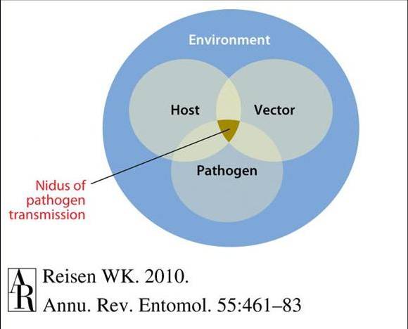
According to Pavlovsky, the nidality (or focality) of disease, where pathogens are associated with specific landscapes, contains three critical elements: (a) competent and infectious vectors, (b) competent vertebrate reservoirs, and (c) susceptible recipient hosts such as humans or domestic animals. This nidality concept combined with landscape ecology has led to the emergence of a new discipline of science called landscape epidemiology, in which diseases may be associated with distinct landscape features or where vector, host and pathogen intersect within a permissive climate.
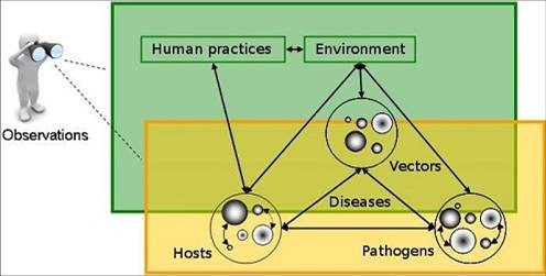
The emergence and re-emergence of vector-borne and zoonotic diseases is controlled by ecosystem changes at the landscape level, in addition to many other factors. An integrated analysis at the landscape scale allows a better understanding of interactions between changes in ecosystems and climate, land use and human behaviour, and the ecology of vectors and animal hosts of infectious agents. Spatial interactions between the agents in a landscape explain patterns of infection risk and may contribute to disease emergence.
Potential Sites for Vector breeding:
Most adult female mosquitoes lay their eggs directly on the surface of water, but some lay in areas that become inundated with water or stagnated with water all the year. Oviposition sites include artificial or natural sites and surface water. Artificial containers include vessels used for water storage or left in the open where they collect rainwater. Natural containers include any plant part that collects water. Surface water includes lakes, rivers, ponds, marshes, swamps, and smaller sites such as puddles and wheel tracks. Irrigated fields also constitute an important source of surface water for some species. Remote sensing and geographical information systems (GIS) provide efficient tools for locating environments capable of maintaining vector populations.
The dependence of developing stages of mosquitoes on aquatic habitats allowed remote sensing techniques to be exploited in identification of these habitats. The surrounding landscape elements that are studied can be related to the geographical range of vector species and the spatial distribution of vector-borne diseases.
Clearing a land for agricultural usage increases the incidence of mosquito breeding, particularly in Rice fields. Agriculture occupies about half of the world’s land and uses more than two-thirds of the world’s fresh water. Agricultural development in many parts of the world has increased the need for crop irrigation, which increases breeding sites for disease vectors.
Studies show the association of mosquito populations to land cover characteristics. Wood et al. (1992) studied the production of Anopheles freeborni in rice (Oryza spp.) fields in California by using remotely sensed growth characteristics of rice and GIS-derived distances to feeding sources. High population of mosquitoes was related to early canopy development and proximity to human settlements. Abundance was related to the quantity of swamp and green pasture, which provided larval habitats.
The analysis of occurrence of various larval habitats and their characteristics in different land cover types indicated that larval habitats and land cover are strongly associated. The most obvious case is irrigated field habitats, which are defined by their land cover. But other significant associations were found, such as the occurrence of stream habitats in forests. The presence of evergreen vegetation usually indicates higher moisture content of the soil and it is significant predictor of the presence of larvae of the mosquitoes. Evergreen vegetation can be easily distinguished from deciduous vegetation by remote sensing in the dry season.
The tropical rain forests are the excellent breeding places of mosquito as the temperature and humidity favor a rapid growth cycle which would otherwise take a longer time. High temperatures reduce the time taken by the larvae to complete the lifecycle. Therefore more abundance can be seen in a shorter time.
Pathogen-Vector-Host interactions are influenced by community structure, landscape and environmental factors. Explaining prevalence patterns requires an understanding of how local determinants of infection, such as community composition, are mediated by landscape characteristics and regional-scale environmental drivers. Once the potential sites for vector breeding have been identified, the next thing to study is the availability of the most susceptible animal or human host. The availability of natural resources in abundance allows human settlement in areas like river basins and areas close to forests. As we have studied, these areas are equally potential for the breeding of mosquitoes. Once a human gets infected through an infected vector, the chance for spreading the disease also increases. The interaction of humans from different communities (settlements) further aggravates the spread of an infection
Remotely sensed information is most useful if landscape elements that are critical to survival of the vectors can be identified through spatial autocorrelation of landscape attributes and also due to biologically meaningful associations.
Role of the diversity of hosts and pathogens in the transmission dynamics of pathogens:
The global climate change has resulted in drastic changes in natural phenomena in many regions around the world. These unhealthy changes are making the humans more susceptible to diseases. These climatic changes can be monitored thorough exploiting various techniques of remote sensing and GIS. Thus by studying the landscape ecology of an area, one can provide an early warning against a disease and also provide solutions for controlling an existing epidemic.
References:
- Eric F Lambin et al. Pathogenic landscapes: Interactions between land, people, disease vectors, and their animal hosts. International Journal of Health Geographics 2010,9:54.
- ELLIS, Brett R. & WILCOX, Bruce A. The ecological dimensions of vector-borne disease research and control”. Cad. Saúde Pública. 2009, vol.25, suppl.1, pp. S155-S167.
- Landscape Ecology from "Colin Stief - Geography Intern at Geography at About.com".
- William K. Reisen Landscape Epidemiology of Vector-Borne Diseases”. Annu. Rev. Entomol. 2010. 55:461–483.
- Impact of Climate Change on Vector Borne Diseases with Emphasis on Malaria (NIMR:http://www.mrcindia.org)
- Moore SM, Borer ET. The influence of host diversity and composition on epidemiological patterns at multiple spatial scales. Ecology. 2012; 93(5): 1095-105.
- www.clermont.inra.fr/epidemiologie_animale_eng/unite/thematiques_et_projets.